Curriculum Overview | "What's on Your Plate?" Outline | Dynamic Runnable Models
The Unit -- What's on Your Plate?
 Before WISE unit: Content and Nature of Models Pre-test
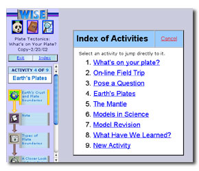
ACTIVITY 1: What's on your plate?
Step 1: Introduction to this project.
Step 2: What do you know? Students describe what they know about the geology of the region nearest where they live (East or West coast).
Step 3: Draw your models. Students draw a model of an earthquake or volcano (West coast only) or mountain building (East Coast only)
Step 4: Explain your model. Students write an explanation of their models.
Step 5: Share Your Models and Explanations. Students post their models and explanations into a shared site..
ACTIVITY 2: On-line Field Trip
Step 1: Introduction to the online field trip.
Step 2: Explore Evidence: Earthquakes in the United States: Students view a map showing real-time data of recent earthquakes in North America.
http://earthquake.usgs.gov/activity/present.html
Step 3: Write a summary note: Students record what they have learned about the occurrence of earthquakes on both the East and West Coast.
Step 4: Explore Evidence: Active Volcanoes in the United States: Students look at real time data of volcanic activity in North America. http://volcano.und.nodak.edu/vwdocs/volc_images/north_america/north_america.html
Step 5: Write a summary note: Students record what they have learned about volcanoes on both the East and West Coast.
Step 6: Explore Evidence: Mountain Ranges in the US: Students look at elevation, contours, and relief maps to determine the location of Mountains in North America.
http://www.nationalatlas.gov/relief.html
Step 7: Write a summary note Students record information about the mountain ranges on both the East and West Coast.
ACTIVITY 3: Pose a Question
Share Your Journal
Step 1: Introduction to Online Discussions
Step 2: Students Pose Questions. With class partner, students come up with one (or two) question(s) that will help them better understand why the geologic processes on the West and East coasts are different and how this is related to the processes inside the earth. Students then post questions in one of four discussion forums (Volcanoes, Earthquakes, Mountain Building, or Plate Characteristics.
ACTIVITY 4: Earths Plates
Step 1: Plate Boundaries. Students view a map illustrating Earths plate boundaries. http://pao.gsfc.nasa.gov/gsfc/earth/pictures/vol_eq_plates.gif
Step 2: Note about plates near you. Students describe the relationship between the location of plate boundaries and the location of the earthquakes and volcanoes in the United States?
Step 3 Introduction to different types of plate boundaries
Step 4: Gathering Evidence: Students explore what happens to Earths crust along each type of plate boundary; transform, divergent, collisional, and convergent.
http://www.pbs.org/wgbh/aso/tryi/tectonics/
Step 5: Reflection note: Students describe the geologic features that are typical for each type of boundary.
ACTIVITY 5: The Mantle
Step 1: Introduction to The Mantle: Students read about convection in the mantle
Step 2: Mantle Circulation. Students observe a cross section of Earth and a dynamic model illustrating convection in the mantle. http://learnertools.com/concord/layers/5-1/layers.html
Step 3: Reflection Note: Students explain how processes inside Earth relate to plate movement.
Step 4: A Closer Look at Mountains and Volcanoes: Students look at several dynamic models that relate mantle circulation to geologic features on Earths surface.
http://learnertools.com/concord/oceanic-continental/5-1/oceanic-continental.html
http://learnertools.com/concord/continental-continental/5-1/continental-continental.html
Step 5: Reflection Note: Students write an explanation of how mountains and volcanoes are formed including details about all the layers of the earth and the role of convection currents in the mantle.
ACTIVITY 6: Models in Science
Step 1: Introduction to What is a Scientific Model?
Step 2 View the Models: Students are given a guide on how to view models.
Step 3: Examine learning partners model:
Step 5: Evaluate your learning partners model. Students use an assessment form to evaluate their learning partners models and descriptions. Prompts include:
- Are the most important features in terms of what causes this geologic process depicted in this model?
- Would this model be useful to teach someone who had never studied this geologic process before?
- What important features are included in this model? Explain why you gave the model this rating.
- What do you think should be added to this model in order to make it better for someone who had never studied this geologic process before?
Step 6: Share Your Evaluation: Students summarize their evaluations and make these summaries available for their learning partners.
ACTIVITY 7: Model Revision
Step 1: Introduction to viewing Students Models
Step 2: View the Evaluation:
Step 3: Draw a Revised Model: Students revise their model based on learning partners critique and Activities 2-5.
Step 4: Explain your new model. Students write an explanation of the new model.
Step 5: Reflection Note on new model. Prompts include:
- I changed my original model of.... because it did not explain or include.....
- My model now includes or helps explain
- My model is now more useful for someone to learn from because it now includes.
- I revised this on the basis of my learning partners critique in the following ways.
- I revised this on the basis of the activities in these WISE units..
ACTIVITY 8: What have we learned?
Step 1: Introduction to on-line forums.
Step 2: Read the Answers Posted: Students read the replies to the questions they posted in Activity 3.
Step 3: Write a Summary to your Questions: Students summarize what they learn from other students about the questions they posed.
Step 3: How can that be? Based on what students have learned, students explain the following:
- How can there be mountains on the East Coast when there is no active plate boundary there?
- What will the coast of California look like in the future?

